Karimnagar | Tourism | Molangoor Fort


By Road

Molangoor or Mulangoor is a small village in Kesavapatnam mandal lying south-east of Karimnagar at a distance of around 30Kms from Karimnagar and 45Kms from Warangal.

By Rail

The nearest railway station is 'Jammikunta' which is on the Kazipet<->Ramagundam line. Molangoor is around 16Km from there.

Profile

Molangoor Fort/Khilla, strategically located on summit of a big isolated granite hill, was built by Oragiri Moggaraju, the Mandalika of the place and a subordinate of Kakatiya Prataparudradeva (A.D. 1295-1323). The ruins of palaces, garrions, stables and other structures stand as mute witnesses to the valor and pride of the fort. The strategic location of the fort itself speaks of the importance it had played during and after the Kakatiya times. There is well known 'Doodh Bawli' or a well of milky water at the foot of the hill inside the fort. The water of the well is found pure as white as milk even today and is believed to have medicinal value

Molangoor was ruled by the Recherla Vala family of the velama caste.The Velama's are of the warrior caste of andhra pradesh from ancient times. Traditionally they have put great value on etiquette and the military virtues and take great pride in their ancestry. They are famous for their truculent code of honour and a fierce pride that led to intrigue, family feuds, and territorial warfare throughout the history Andhra pradesh.

The Vala chiefs were the feudatories of the kakatiya empire. This fort was one of the strong hold of the kakatiya kings. Along with deverakonda and rachakonda (recherla velama forts ) mulangoor used to act as a shield for the kakatiyas against the invading armies.

Karimnagar | Tourism | Ramagiri Fort

Ramagiri Fort / Khilla is situated in Kamanpur village at around 60Km from Karimnagar.

By Road

This fort is on the way while going from Karimnagar to Manthani. One need to follow the Karimnagar-Manthani road till Begumpet X roads and take right diversion there to reach the Begumpet village. The fort is around 2Kms from there and can be reached only on foot.

By Rail

The nearest railway station is 'Peddapalli' which is located on the NewDelhi<->Kazipet line. Ramagiri Khilla is around 20Km from there.

Profile

Ramagiri Fort, often referred as Ratnagarbha has as ancient fort believed to be used by Satavahanas and Kakatiyas as their Military establishment. This fort is remarked as the unconquerable fort is Telangana region. The hills and surroundings here are astounding to watch and contain many herbs of medicinal importance.

Ramagiri also has a temple of Sita and Rama with a Linga(incarnation of Lord Shiva) believed to be installed by Lord Rama. You can see the foot prints of Lord Rama & Sita here, supporting the claim that both stayed here for some time during there visit. Other attractions here are Sita’s vermilion box, Ganga Gouri wells, Gouri gundam, Brahma gundam, twin horses of Matsya kachpa, Mallvanam and Brindavanam.

Karimnagar | Tourism | Elgandal Fort


By Road

Elgangal or Veligandula is a small village in Karimnagar district, lying at around 10Km west of Karimnagar on the Karimnagar-Vemulawada road.

By Rail

The nearest railway station is 'Peddapalli' which is located on the NewDelhi<->Kazipet line. Elgandal is around 45Km from there.

Profile

Elgandal (some times spelt as Elagandal) is an ancient village with grand history. In olden days it was called as Bahudanyapuram. But it was known as Veligandula from Kakatiya times. This place has the historical significance of being ruled by 5 important dynasties - Kakatiyas, Musunuri Nayaks, Recherla Padmanayaks, Qutubsahis and Asaf Jahis(Nizams). Well-known poet Veligandula Narayana hails from this place. He has completed the lapses found in the Bhagavata of great poet Pothana. It is believed that he has composed the last two (11th and 12th) skandhas of Potana Bhagavathamu during 15th century A.D.

Elgandal Fort/Khilla

The fort of Elgandal played an important role from the period of the Kakatiyas to the Asaf Jahis in the history of the Deccan. It is situated on the banks of the Manair river amidst palm groves. The antiquities of the place worth mentioning are, Brindavan tank on the outside of the eastern gateway of the fort built by Zafar-ud-Doula in 1754 A.D. with minarets that oscillate when shaken, the mosque on the top of the hill and the temples of Neelakanthesvara and Narasimha Swamy lying on the hill fort.

The Narasimha Temple

After the mosque at lower level, there is Narasimha temple facing the east consisting of three separate rooms side by side with an open-yard enclosed by walls. The deity is noticed in the central room with Tripundras or three Namas on a black stone, which is worshipped as Narasimha swamy by the villagers.

Karimnagar | Tourism | Dhulikatta


By Road

Dhulikatta is a small village located at around 28Km from Karimnagar city and 5Km from Eligedu & Julapalli Mandal headquarters. One can follow the Karimnagar-Katnapalli-Eligedu-Dhulikatta route to reach this place. Katnapalli is located on Rajiv Rahadari(SH1) connecting Karimnagar-Peddapalli at a distance of around 20Km.

The actual Stupa is 4Km inside the village located on the banks of Hussainimiya Vagu amidst the agricultural lands. This place is not reachable on a car. You can go on a 2-wheeler to some distance and take a walk from there to reach this rather neglected historical monument.

By Rail

The nearest railway station is 'Peddapalli' which is located on the NewDelhi<->Kazipet line. Dhulikatta is around 23Km from there.

Profile

Dhulikatta is an important Buddhist site which contains many Buddhist stupas of the Satavahana period and one of the 30 walled cities mentioned by Megasthanes in his travel account, the Indica. Excavations have dated the site to have flourished between the 2nd Century BC to 2nd Century AD. The artifacts unearthed include remains of gateways built of light bricks, Mahastupas, residential houses, wells, punch-marked coins, Roman and Satavahana coins and seals. Experts estimate that forty-seven slabs were used to decorate the dome of the Stupa here. Remains of Chatra, Buddhapada, Charmachakra Stupa etc used to symbolically represent Buddha were found here. Other excavations have discovered Brahmi inscriptions on ayaka slabs and an ivory seal at the site. The bronze/copper idol of mother and child known as Ankadhatri is another important find.

Route Map

Nalgonda | Tourism | Bhuvanagiri Fort

This fort is around 48Km from Hyderabad, the state capital of Andhra Pradesh. It is located towards the east of Hyderabad on Warangal Highway. It is well connected by Road and Rail.

By Road

All the buses operated by APSRTC from Hyderabad to Warangal or YadagiriGutta has a halt at Bhuvangiri.

By Rail

Bhuvanagiri also has a railway station falling on the Hyderabad-Kazipet Route of South Central Railways. Few express trains like Telangana/Golconda/BhagyaNagar/Krishna has a stop here.

Profile

Bhuvanagiri Fort is a perfect weekend destination for those who are interested in doing some adventure and trekking. It takes around an hour to reach the place. The fort is built on a huge naturally formed huge single rock which is visible from even 5km distance. May be that could be the reason why the erstwhile kings choose this location for building a fort. There are not many reminisces at present reminding the past history. But, trekking of the huge rock is thrilling. The view from the top is breath taking. A nice place to visit if you are willing to burn some extra calories. Avoid going on a sunny day and carry waterbottle/snacks along with you while trekking as there is hardly anything available on the top . Finally, don't forget to carry a camera with you to capture the rather neglected past history.

As per the history, the Fort was built on the isolated monolithic rock by the Western Chalukya ruler Tri-bhuvana-malla Vikram-aditya VI and was named after him as Tribhuvanagiri. This name gradually became Bhuvanagiri and subsequently Bhongir. At the foot of the fortified rocks stands the town of Bhongir, it has a unique egg-shaped construction with two entry points protected by huge rocks, so the fort was considered practically impregnable by invading armies. A moat that encircles the fort, a vast underground chamber, trap doors, an armoury, stables, ponds, wells etc., make for fascinating viewing. The Bala Hisar or citadel on the top of the hill gives a bird's eye view of the neighbouring area. The fort is associated with the rule of the heroic queen Rudra Amma Devi and her grandson Pratapa Rudra. According to legend, there once was an underground corridor connecting Bhongir Fort to Golconda Fort.

Route Map


Hyderabad | Tourism | Charminar

Charminar, meaning "Four Towers" or "Mosque of the four minarets") is one of the most important monuments in the city of Hyderabad, capital of the state of Andhra Pradesh, India.

The monument was built by Muhammad Quli Qutb Shah in 1591 to commemorate the eradication of plague, shortly after he had shifted his capital from Golkonda to what now is known as Hyderabad[1]. Legends has it that the emperor Quli Qutb Shah prayed for the end of plague and took the vow to build a masjid on that very place. He ordered the construction of the masjid which became popular as Charminar because of its four characteristic minarets (possibly depicting the first four khalifs of Islam)

The monument was built by Muhammad Quli Qutb Shah in 1591 to commemorate the eradication of plague, shortly after he had shifted his capital from Golkonda to what now is known as Hyderabad[1]. Legends has it that the emperor Quli Qutb Shah prayed for the end of plague and took the vow to build a masjid on that very place. He ordered the construction of the masjid which became popular as Charminar because of its four characteristic minarets (possibly depicting the first four khalifs of Islam)

History

The Charminar is a beautiful and impressive square monument, with each side measuring 20 m, and each of the edges having a pointed high minaret. It derives its name from these four gracefully carved minarets which soar to a height of 48.7 m above the ground, commanding the landscape for miles around. Charminar literally means 'Four Spires' (Char (Hindi) = four, Minar (Arabic manara) = spire/tower).

Each minaret has four stories, each looking like a delicately carved ring around the minaret. Every side opens into a plaza through giant arches, which overlook four major thoroughfares and dwarf other features of the building except the minarets. Each arch is 11 m wide and rises 20 m to the pinnacle from the plinth. Once upon a time each of these arches led to four royal roads. Each of the four arches has a clock which were put up in 1889. The monument overlooks another beautiful and grand mosque called Makkah Masjid.

There are two galleries within the Charminar, one over another, and above those a terrace that serves as a roof, bordered with a stone balcony. It is vaulted underneath and appears like a dome. There is a large table raised seven or eight feet from the ground with steps to go up to it. Nothing in the town seems so lovely as the outside of that building. A thriving market still lies around the Charminar attracting people and merchandise of every description. In its heyday, the Charminar market had some 14,000 shops, a unique conglomeration of a grand oriental bazaar. The whole market around the Charminar is crowded with shops which sell glass bangles in rainbow colors.

Unlike Taj Mahal, the fluted minarets of Charminar are built into the main structure. Inside the four-storied minarets 149 winding steps guide the visitor to the upper floor, the highest point one can reach, and providing a panoramic view of the city. There are 45 prayer spaces with a large open space in front to accommodate more for Friday prayers.

Built with granite and lime mortar, Charminar is a fine example of the Cazia style of architecture[3]. Locally available granite, sand and lime were used in the construction of Qutb Shahi monuments including Charminar. Lime used for the plaster seems to have been specifically ground and treated to give durable stucco. Generally shell, lime, jaggery, white of egg, etc. are known to enhance the binding property of lime. The SiO2 /CaO ratio in Charminar’s mortar and plaster (1.61-2.25) indicates that the engineers at that time were probably aware of the necessity of having a higher Sio2 content but were not sure of the optimum value (presently the common practice is to have 3.0) at which the maximum strength of lime cement could be obtained.

The Charminar looks spectacular particularly in the nights when it is illuminated. This graceful monument is very beautiful on the inside, and is particularly known for its carvings and moldings. The painstaking details result in a graceful, lace-like look.

Route Map


View Larger Map

Hyderabad | Tourism | Golconda Fort


Golkonda (or Golconda), a ruined city of south-central India, is situated west of Hyderabad, capital of ancient Hyderabad state (c. 1364–1512).
It later became one of the five Muslim kingdoms of the Deccan known as the Deccan sultanates, until it was captured by the Mughal Emperor Aurangzeb's forces in 1687. Aurangzeb besieged the fort for nine long months. If it were not for the treachery of a staff who opened a side gate, Golconda would have held out longer.
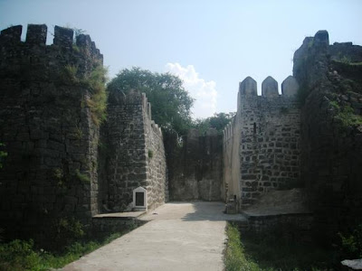
Three granite walls of megalithic construction surround the Golconda Fort, with the outermost wall having a circumference of about 7 km.The most important builder of Golconda was Ibrahim Quli Qutb Shah Wali, the fourth Qutb king. Ibrahim was following in the spirit of his ancestors, the Qutub Shahi kings, a great family of builders who had ruled the kingdom of Golconda from 1512. Their first capital, the fortress citadel of Golconda, was rebuilt for defense from invading Mughals from the north. They laid out Golconda's splendid monuments, now in ruins, and designed a perfect acoustical system by which a hand clap sounded at the fort's main gates, the grand portico, was heard at the top of the citadel, situated on a 300-foot (91 m)-high granite hill. This is one of the fascinating features of the fort.
Golconda consists of four distinct forts with a 10 km long outer wall with 87 semi circular bastions; some still mounted with cannons, eight gateways, four drawbridges and number of royal apartments & halls, temples, mosques, magazines, stables etc, inside. The lowest of these is the outermost enclosure into which we enter by the "Fateh Darwaza" (Victory gate, so called after Aurangzeb’s triumphant army marched in through this gate) studded with giant iron spikes (to prevent elephants from battering them down) near the south-eastern corner. At Fateh Darwaza can be experienced the fantastic acoustic effects, characteristic of the engineering marvels at Golconda. A hand clap at a certain point below the dome at the entrance reverberates and can be heard clearly at the 'Bala Hisar' pavilion, the highest point almost a kilometer away, this worked as a warning note to the royals in case of an attack.
Bala Hissar Gate is the main entrance to the fort located on the eastern side. It has a pointed arch bordered by rows of scroll work. The spandrels have yalis and decorated roundels. The area above the door has peacocks with ornate tails flanking an ornamental arched niche. The granite block lintel below has sculpted yalis flanking a disc. The design of peacocks and lions is a blend of Hindu - Muslim architecture.
Toli Masjid, situated at Karvan, about 2 km from the Golconda fort, was built in 1671 by Mir Musa Khan Mahaldar, royal architect of Abdullah Qutb Shah. The facade consists of five arches, each with lotus medallions in the spandrels. The central arch is slightly wider and more ornate. The mosque inside is divided into two halls, a transverse outer hall and an inner hall entered through triple arches.

History

In the 16th century, Golconda was the capital and fortress city of the Qutb Shahi kingdom, near Hyderabad. The city was home to one of the most powerful Muslim sultanates in the region and was the center of a flourishing diamond trade. Golconda is located 11 km west of the city of Hyderabad, Andhra Pradesh state, India (location [show location on an interactive map] 17°23′00″N, 78°24′15″E).
According to a legend, the fort derives its name from Golla Konda, which is a Telugu word for Shepherd's Hill. It is believed that a shepherd boy came across an idol on the hill. This led to the construction of a mud fort by the then Kakatiya dynasty ruler of the kingdom around the site.
The city and fortress are built on a granite hill that is 120 meters (400ft) high and is surrounded by massive crenelated ramparts. The beginnings of the fort date to the 1143, when the Hindu Kakatiya dynasty ruled the area. The Kakatiya dynasty were followed by the state of Warangal, which was later conquered by the Islamic Bahmani Sultanat. The fort became the capital of a major province in the Sultanate and after its collapse the capital of the Qutb Shahi kings. The fort finally fell into ruins after a siege and its fall to Mughal emperor Aurangazeb.
After the collapse of the Bahmani Sultanat, Golconda rose to prominence as the seat of the Qutb Shahi dynasty around 1507. Over a period of 62 years the mud fort was expanded by the first three Qutb Shahi kings into a massive fort of granite, extending around 5 km in circumference. It remained the capital of the Qutb Shahi dynasty until 1590 when the capital was shifted to Hyderabad. The Qutb Shahis expanded the fort, whose 10 km outer wall enclosed the city. The state became a focal point for Shia Islam in India, for instance in the seventeenth century Bahraini clerics, Sheikh Ja`far bin Kamal al-Din and Sheikh Salih Al-Karzakani both emigrated to Golconda[2].
The Qutb Shahi sultanate lasted until its conquest by Mughal emperor Aurangzeb in 1687. The fortress held out against Aurangzeb for nine months, falling to the Mughals through treachery.
Kancharla Gopanna, popularly known as Bhaktha Ramadaasu, a devout Hindu who constructed Bhadrachalm temple without informing the sultan at that time [Tana Shah], was kept in a jail located inside the fort.

Route Map